Getting back underway, both with sailing and volcano excursions, was so revitalizing, I was on a roll to Mexico and keen to put some miles on the log and go climbing again.
The first challenge however was to safely cross the dreaded Gulf of Tehuantepec, where gap winds funnel across the narrow belt of land separating the Caribbean and the Pacific generating full blown storm conditions that have taken many boats and their crew to Davey Jones' locker.

Everyone I'd met had their stories of good and bad crossings, and there were some horror stories, including reports of recently drowned solo sailors and boats being sandblasted by the gap winds even though they were hundreds of miles west of the gulf.

Without exception everyone also recommended Enrique who manages the Chiapas Marina as a weather window guru. He apparently gets it right every time.
I had barely tied up at Chiapas when a window was due, and Enrique was (reluctantly) advising me that if I didn't want to wait at least another 8 days I should get myself in position now. (It's a full day sailing from Chiapas to where you first encounter gap winds so if it's a small window you need to get out there and ready to make the jump as soon as the winds ease.)
So after clearing in, and taking a taxi to the customs authorities back on the
Nicaraguan/Mexico border to obtain a TIP ( temporary import permit) for Whakaari, I was busily refueling and preparing to meet the infamous T-pecker.


Happily I chose to take some time out and have dinner with a newly wed couple from BC who were
on an extended
sailing honeymoon - they're so much fun!
Twenty four hours later as the sun sets I'm putting two reefs in the main and locking everything down, brewing up some soups and coffee for the thermos, as I close on the gap wind area, the windspeed steadily rising and the sea state building.
By 0200 hrs Whakaari has a bone in her mouth, the rail is occasionally under, and we're cracking along at 8-9 knots.
By 0600 hrs I've shaken out both reefs, under full headsail, maintaining 6-7 knots and praising Enrique for another good call!
The winds die out but the time flows along nicely and I make landfall in the wee small hours in Bahia Conejo. The 250 nm took 46 hours, so no records broken but a fun run, easy conditions, with magnificent starry nights and many turtles just floating about. I saw only one other boat making the crossing, a catamaran heading south, but they didn't have their radio on.
The only issue was the auto pilot twice turning me back 180 degrees while I was trying to get some shuteye - it's like a stubborn horse, reluctant to head out but give it half a chance and it'll turn for home in a shot!

 Over the next few days I skipped along the Central Mexican Coast, picking the eyes out of a fabulous cruising area that North American boaters return to year in year out to explore at a much more leisurely pace than I. Some of the highlights - Huatulco National Park's golden sands & turtle nesting beaches, Acupulco and cliff divers,

Escondido and its "Mexican Pipeline", Puerto Angel's panga cluttered bay with Tuna season in full swing, and of course Zihuatenajo, a fabulous mix of old and new that I would come to know better, but after a volcano climbing excursion inland.
In Mexico there are some 40 significant volcanoes, with a huge range in elevation, thermal activity and difficulty of the climb, the highest being Pico de Orizaba at 18,620'
Several are closed as they are currently erupting, or have been for some time and considered dangerous in particular Popocatepeti (17,800') though I heard of several undercover ascents
My crew for the next sailing segment, Carol a Canadian who escapes to Mexico during the northern winter and lives in Barra de Navidad suggested I consider climbing Colima (12,630') which is close to Barra and would give us a chance to meet up before being committed to sharing a 40' boat and no simpatico.
Colima is a dual volcanic complex locally called "Fire and Ice" - Fuego (Fire) is currently active and closed to visitors, and Nevado (Ice) tho quiet now is potentially active but open to hike and climb. There are some technical routes on this 4,000m volcano and the close proximity to its active twin presented the possibility of some great views! Sounds like a plan!

After the chicken buses of my last inland trips, Mexico's long haul buses were luxury, often complete with onboard toilets, 110v power outlets at your seat, wifi and movies, and as there's plenty of competition they're not expensive. The terminals range from swanky departure lounge style to noisy food-stall pavements, but always with helpful staff, no hassling from vendors, a secure luggage system, and I had many fun interactions with local travellers.

Carol was house sitting a friends place that was a tropical retreat, and she gave me the Cook's tour of her second home town, and introduced me to her friends there. We met up with Judy and Bill of "Moontide" at Grand Bay as they headed south. Carol had crewed for them also.

I met so many Canadians in Barra, just like all the other places I'd visited along this idyllic coast, I hope whoever left BC last turned the lights out!
A recent storm had ripped out some of the beach access points and the expat Canuks held a fundraiser while I was there, with traditional Mexican fare, silent auctions and a funky local band.


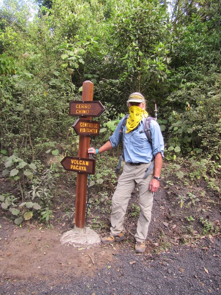
But I needed to go find "Fire and Ice", so onto another bus, packing my camping & hiking gear, crampons & ice axe and I headed inland.
The last leg involved another chicken bus, complete with animals this time, and I jumped off where the dirt road starts its ascent to La Joya and the Colima national park HQ. A long steep 17 km through coffee fincas, then tall oak and spruce stands, and finally native forest (the only place in the world with Abies colomensis forests. I walked most of it, getting a lift for the last 4-5 km with a bombadero (firefighters) truck delivering water. I happily threw my pack in the back by the tank and assailed the driver with my Spanglish. When we got to the gate my pack was soaked - Doh!
A short two klicks to the campsite and I was setting up just on dark, as the temps plummet. A fire becomes top priority, and thanks to the logging operations (to remove exotics planted into the native forest years ago) there's an endless supply of firewood. The logging crew is also camped nearby (no down sleeping bags, MSR stove etc, for them, just the clothes they're wearing and
some meat cooked on sticks) so they have an impressive bonfire to keep their large crew warm. The jokes and singing went late into the night.
 By 4 am I'm ready to get moving, surprised how cold it was at only 3000m asl, but not before stirring the fire up again, and finding a place to stash my camping gear.
The trail is kinda marked, but you have to be focused, especially walking by headlamp. The compass was well used. For two hours it's just a creek bed, then forest changes to a unique forest and alpine tussock mix before suddenly arriving at bush line, and it's all ash, rock and snow. At 7am, sunrise, I'm climbing the east flank above the transmitter towers, heading towards a snow-filled couloir that looks to lead onto a spine and the summit. It's a technical route apparently but the going was pretty good.
 Before gaining the summit I'd passed three permanent anchors, and I wasn't using a rope or protection, so they must guide people without climbing experience this way.
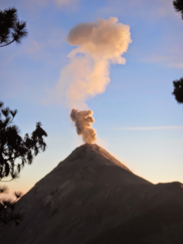
Just as I crested the spine, with only 200 m to the summit, Fuego erupted! I felt and then heard it, and had to check myself, to not hurry the last few moves so I was able to see it.

For me that was one of those "pay dirt" moments, a validation of all that I'd planned to achieve on this escapade. I was right here, in the moment, the effort was being paid back in spades - It was challenging, exhilarating and so rewarding!

I stayed nearly two hours on the summit of Nevado de Colima, as Fuego just kept pumping, and the 360 degree views were mesmerizing. Researchers turned up in a helicopter, getting as close as they dared to Fuego, so that provided some extra entertainment.
 Two other climbers were supposed to be on Colima as well. They camped in a different location to me but I thought we would meet up,somewhere on the mountain but I didn't see them until I was almost back on the flat lands.
Descending I almost took a major fall. I was taking a shortcut to an ash scree below so I could glissade down, but a rock crumbled under my boot, and to avoid being pitched forward and over a 50 meter bluff beyond the ledge I had to take the drop leaning my weight ( and pack ) backwards so the impact when I'd dropped only 2 metres onto the ledge below went straight up thru my left leg. It felt like I'd broken something, but the pain subsided quickly and I could move freely. So much so I glissaded the entire ash and snow section right to the bush line.
The walk out was enjoyable and I felt very pleased with myself.
The logging chief had offered me a ride down the 17 km access road if I waited for him at Park HQ, which of course I did, resting aching legs, brewing up in the shade of an Abies and writing up the day. He and I managed to converse on the drive down, and it was like being back in a forestry truck, smells and sap of Pine on everything, 2 stroke fuel and chainsaws in the back, a Forester and a Timber man pointing out only things we could appreciate. He loved to drive as close to the edge as possible so,I could look down on the forest canopy and the gorges far below.
Back in Cuidad Guzman, I'm looking forward to celebrating at a cafe before the long and involved bus trips back to Ixtapa where Whakaari is no doubt feeling neglected. But everybody is so helpful and the buses are so frequent, I find myself on a bus without a break. The views of "Fire and Ice" from the road, of ash clouds still spreading out across the country and coloring the sunset like you wouldn't believe, was a nice way to finish a very long day (oh, and I did
manage to get two cold beers and some snacks at the terminal to take aboard😅 )