Pages

Friday, April 10, 2015

Guatemala and El Salvador

My eventual escape from Costa Rica was a fast sail across Golfo de Papagayo but only after sitting out a gale in the protected anchorage of Bahia Santa Alena. Four yachts weathered the gusts, waiting for the winds to ease and head north or south. The morning I chose to leave I was delayed an hour searching for my SUP which had been ripped away from the boat and blown across the bay. I found it wedged in the mangroves as if wanting no part of my journey.

8.9 knots under double reefed main


 With two reefs in the main and a pocket handkerchief of a headsail, Whakaari charged across the gulf at 8-9 knots, shaking off the foaming seas, rounding up occasionally in gusts of 35 knots plus, settling nicely to her work. The first of two notorious gap winds was an exhilarating but confident sail.
By midday I'd shaken out one reef and set both headsails, and we were passing Nicaragua's San Juan del Sur (a popular surf beach crowded with Aussies), on our way to the gulf of Fonseca, where three countries meet - Nicaragua, Guatemala and El Salvador.
At sunset we were still charging along on a reach under full sail, and I had made the decision to carry on direct to Bahia del Sol, El Salvador and wait off the bar til morning for a pilot.
Three countries in one day! The line of volcanoes along their coastlines an impressive sight, especially at dusk and dawn. Absolutely fantastic sailing!

Passing over the bar was my first hazardous encounter with potential grounding since the "Costa Rica Incident" and I don't mind admitting I was very anxious. Happily it was all over quickly and I was being welcomed at Bahia del Sol Marina with a rum cocktail and the easiest most enjoyable "clearing in" process ever.
The cruisers there were all gearing up for the El Salvador cruisers rally, and in fine form. I was welcomed like an old friend. There I met people who had shared in a similar experience of protracted repairs in Quepos, was put in contact with crew for going north that worked out exceptionally well, and given endless invaluable advice for cruising in North America. One expat, Lou, opened his home to cruisers every Sunday afternoon for pot luck BYO drinks and dinner, where we watched the Superbowl final.
However my focus was to notch up some volcanoes, so I very quickly headed out on a "chicken bus" to San Salvador, and boarded a coach to Guatemala.
In one day I made it to Antigua, the delightful World Heritage listed city near Guatemala City populated with expats, touristas, Catholic monasteries & churches, and surrounded by impressive volcanic peaks.
Fuego and Acetenango from a plaza in Antigua

Monastery Ruins
Above the catacombs

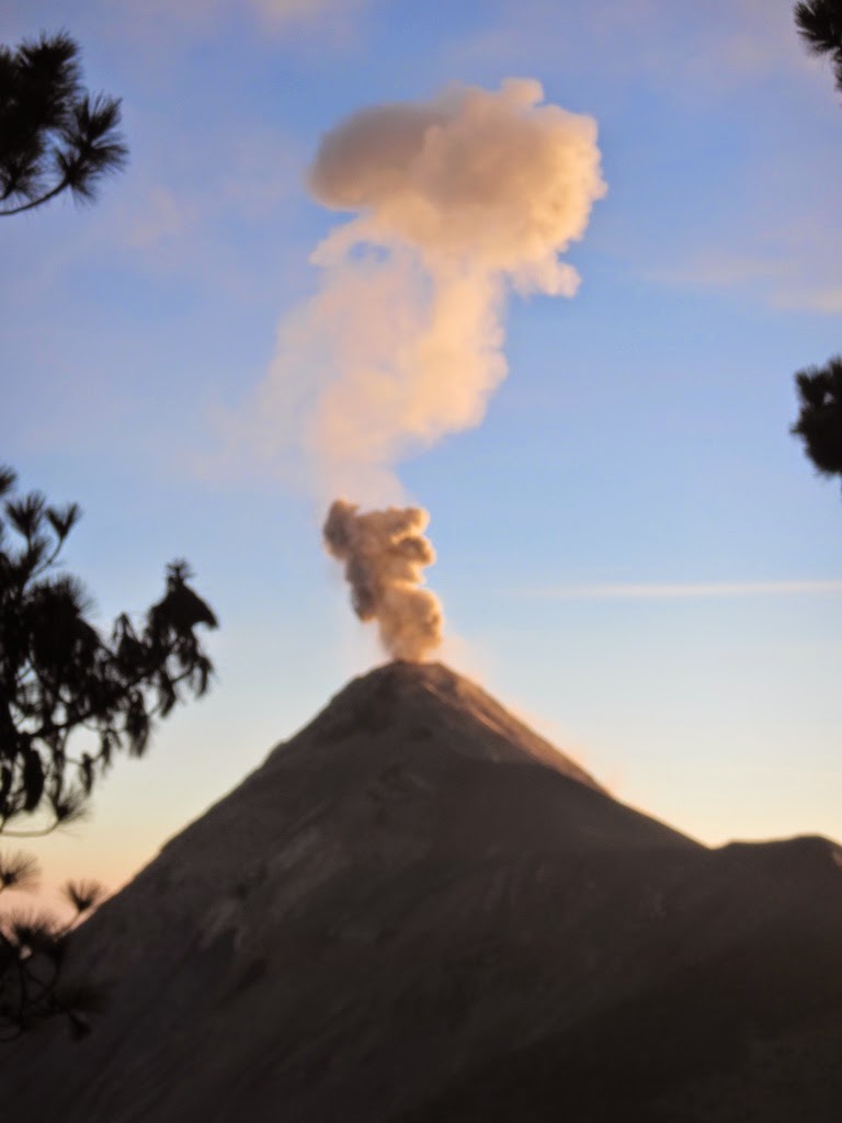
OX Expeditions offered overnight hikes on Acetenango and that was the closest I would be able to get to Volcan Fuego, currently very active and providing impressive displays.
Acetenango is Central America's third highest volcano at 3976m (13,044') and last erupted in 1972.
Twelve of us hiked up to base camp at 3400 m asl and enjoyed some stunning ash eruptions and lava flows from the time we arrived at 4 pm right through the night and again during our sunrise summit of Acetenango.

Into Cloud Forest again


Tussock and Pines at sub-alpine altitude!


Even though it was an arduous climb with moderately heavy packs, our group clicked early, making the overnight hike a social time esp. around the fire at night with songs, stories and wine. I chose to sleep under the stars to see as many pyroclastic flows as possible, and tho there was a layer of ice on my bag at dawn and regular breaks in my sleep with every rumble it was totally worth it. I was to hear two days later that this activity was just a warm up - Fuego erupted on February 7 as I was returning to El Salvador, pushing ash plumes 5000' above the summit, ash falling on Guatemala City, and closing the international airport.


I must have got some rest as in the morning as the final climb to the summit was easy, and I even took part in the crater rim run and earned a free t-shirt. Second fastest in the group, not bad for an old guy, huh?

Acetenango Summit at Sunrise


While in Antigua I also hiked around the flanks of Pacaya as a warm up to the overnite hike, visited a couple of monastery ruins and soaked up views of Volcan Agua that dominates the city.

Great Coffee!


(Antigua's climate is so consistently benign that priests of old chose it over all others and resulted in many churches being built there. However most have been destroyed by the equally consistent earthquakes)
Dragging myself away from this cultural oasis, I took another chicken bus out and returned to El Salvador, making my way toward Santa Ana.
My run of luck with public transport was out by now, and my rudimentary Spanish not up to the task. I found myself out of light, hitching a quiet road alone in a region of dubious integrity. I got on a crowded bus and stayed on it till reaching a major town where I could get a room for the night. Of course that place was nowhere near my destination and I would need a new route in the morning. It turned out to be Sonsonate, a down at heel town boasting the highest stats for murder, prostitution and drug cartel activity in the whole country!
At dawn I'm out of the filthy hotel like a shot, scouring the bus terminal for a bus to Santa Ana. The one I chose dropped me at a junction high in the Parque National Cerro Verde above Lago Coatepeque, a stunning lake in a massive caldera, 12 km short of my destination, with only 2 hours to get to the meeting point for the volcano hike.

Frozen icecreams on a hot day, n
o ice in his carry box just paper!


After walking the first 4 kms I was picked up by a young enthusiastic couple going to a election campaign at the Park's campground. We drove past many coffee pickers, chatting about El Salvador politics until the car broke down 2 kms short of the park entrance. In the end I made it in time to join the day's tour. It is illegal to climb Volcan de Santa Ana without a park guide and an armed guard, and they leave at 11 am sharp.
The group was large, with many El Salvadorians, as it was a Sunday. We paid two dollars each on three separate occasions to park staff and land owners as the trail made its way upward, and in two hours reached the crater rim, a height gain of only 900 metres. It was my first experience of buying an ice-cream from a vendor on a crater rim! You have to be enterprising in this poor country.
The Santa Ana Volcano, or Ilamatepec, is a large cinder cone. At 2,381 metres above sea level, it is the highest volcano in the country. It last erupted in 2005, forcing the evacuation of villages and killing two people. The crater is a set of nested calderas and contains an impressive lake similar in color to the glacial lakes back home.

 
During this hike I met a Romanian traveller who only hiked and climbed volcanoes for his vacations! He was wealth of knowledge about Central American volcanology.


My return to Whakaari on anchor at Bahia del Sol was delayed a day as I missed the last bus out of San Salvador while buying provisions. So, another $7.50 room, cleaner but still of dubious reputation (no mirror in the bathroom but plenty round the king size bed) and lots of comings and goings!
All was well on my return, and I was looking forward to another Sunday session with the cruisers, but my body decided I needed a rest and I slept through til the evening, meeting everyone coming back from Lou's as I belatedly headed up river in my dinghy with a hastily made pasta dish. I was sorry to miss that occasion as I wanted to pick people's brains about points north to Mexico.
I cleared out of El Salvador the next day and crossed the bar early Tuesday morning in the company of Steve and Trish on Kuyima, they heading sound, me turning north to Chiapas, Mexico, and my next challenge, the Tehuantepec gap wind.


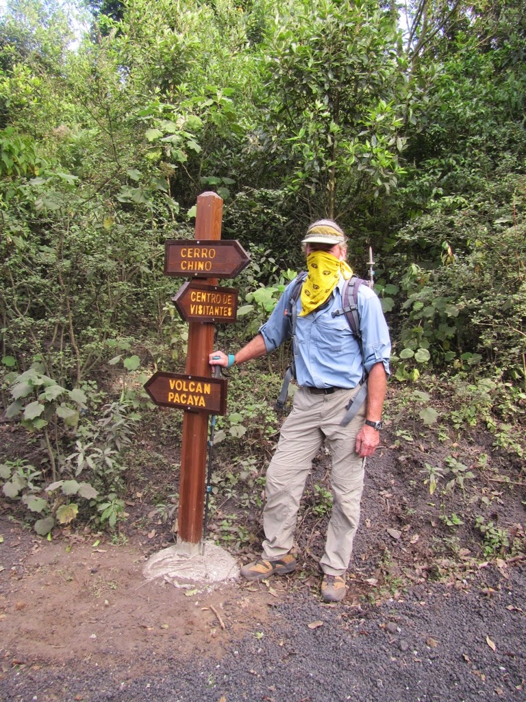
Volcan Pacaya Hike -
The volanic ash is so fine it
floats up when  you walk,
so a bandana is a great filter.


Toasting Marshmallows in cooling lava


Preparing to leave Bahia Del Sol at dawn

Nicaragua

Back in September last year I was off to explore this Central American hotbed of revolutionists, coffee, rum and volcanoes.
One month with Lizzie, intent on climbing and hiking, mixed with local culture and cuisine, Whakaari safe n secure in Puntarenas, Costa Rica.


We met up in Managua, Lizzie in from Colorado, me straight from a turtle nesting/ kite surfing beach on the border with Costa Rica, picked up a rental car, and after some luxury R&R at the Hilton Managua headed out on a hastily planned circuit of this diverse, yet tiny country of 6.2 million proud people.


First stop, Volcan Masaya, an active and easily accessible complex with bubbling lava and sulphurous gases, actually inside a massive ancient crater El Ventarron, where we hiked around the rims of the two main cones.

Laguna de Apoyo
Below we could see our base for the next two days, Laguna de Apoyo, a sapphire colored 200 century old crater, the country's deepest and cleanest, with undersea fumeroles.
Granada Church
Our accommodation (purchased and upgraded very recently by a fun loving German who fell in love with the place on a backpacking trip ) was just perfect, on the lakeshore, kayaks free to use or just dive in.

Spider Monkeys on a Las Isetas isle
From here we visited the gorgeous colonial town of Granada, took a panga tour of the unique Las Isetas, and climbed Volcan Mombacho
One of the 365 islets of Las Isetas 

Something unusual - freshwater bull sharks still exist in Lake Nicaragua, feared for their viciousness just like their saltwater cousins, but also farmed and harvested for decades.


Our Mombacho Guide


Simple form and function in the Cloud Forest
We encountered track workers on Mombacho and chatted
with the park manager who was really in tune with his environment


Lizzie found a finca (farm estate) called Selva Negra (or Black Forest) to check out and we ended up staying there for two days horse trekking, walking their cloud forest trails and touring the estates orchards, stock farm and coffee plantation. The restaurant featured food grown on the finca, and seemed popular with both locals and tourists.


From there we headed for the northeast corner of Nicaragua to climb the country's highest peak Mogoton, (6910')on the border with Honduras.
A guide was essential as the ridge to ascend Cerro Mogoton had also been access for the Sandanistas, and had been covered with land mines in the 1980s. A narrow strip had been cleared but you didn't want to stray off the trail.
The day started at 6am, meeting our guide at Ocotal's central square, and happily a coffee cart already busy with local customers.
Our rental 4x4 was perfect for the scoured sand track ( a logging road now) to the trailhead, involving several river crossings and avoiding major slips off the track down into the steep forested gorges.
The route started at a family's small coffee plantation, and after a courtesy call at their simple cabin we plunged down into the Achuapa riverbed of house boulders and fast flowing water. Soon the real climb began, taking a direct line through cloud forest jam packed with bromeliads, up to the main ridge. Monkeys fed noisily above us as we steadily gained the ridge.
Sticking close behind our guide, passing the occasional survey peg marking the Honduras- Nicaragua border, we reached the summit at
midday
                             
With no view, and rain clouds threatening, it was a quick stop before retracing our steps. We'd climbed 2680' over five hours, and enjoyed the whole experience.


Back in Ocotal we revisited the square which had become a town icon as a previous Mayor had developed the grounds with fantastic landscaping, and now spent his days care-taking his pride and joy.
From there we took the back roads through the region, making our way to Somoto and then onto Leon where we'd base ourselves to climb a number of volcanoes.
The drive was fascinating, especially as it was a Sunday, and various activities were underway along the route- markets, family picnics, drunkards on the road, a motocross event, horsemen strutting their stuff. Judging by the looks we received, foreigners are seldom seen in these parts.
The region was experiencing a drought, and times were hard for the farmers,their crops failing. But because the rains hadn't come, the Somoto Canyon was 10' lower than usual for October, and canyoning trips were still on, so in we plunged.

The family had a great little operation, with the youngest son clearly the mover and shaker. We were met at a cafe in the town without any directions or locations being exchanged- we'd been noticed and word was out. The canyoning package included meals at their home, a menagerie of typical animals, and Cabinas too if you needed accommodation. So all the family had a role, tho Papa took the easiest, surveying proceedings from his hammock and cracking jokes for the touristas.

Recommended, we stayed in Esteli at a B&B and visited the Cuban run Horizon Cigar Factory that does custom orders for clients. The boxes, labels, shape of cigar, and the leaf used are all made or selected to order. The staff, and the atmosphere, surprisingly relaxed and friendly.

Leon's central Plaza
Sandinista Revolution Museum

Heroes of the revolution

Leon is a tight grid of churches, casas , eating places, once the capital of Nicaragua, and proudly the HQ for the Revolution. As such it's a destination for many visitors. There are a number of outfitters and guiding operators taking tours to the numerous volcanoes, and the nearby beaches of Ponelaya and Las Penitas are popular.
Las Penitas Beach - Pirate Bar

QuetzalTrekkers loaded up and ready for adventure

We had heard about Quetzaltrekkers, an organisation that gives all it's profits to local school projects, and staffed with volunteers. We decided to book with them, and were soon signed up on three trips - a moonlight hike up Telica (3481') an active stratovolcano, an overnight trek to three separate volcanoes which started with volcano boarding on Cerro Negro, and a challenging ascent of San Cristobal, the country's highest volcano at 5,725', and recently active with devastating impacts on the local villages.
Telica Crater Rim

I even managed to ski Cerro Negro,
making some passable parallel turns on
volcanic ash on an old pair of Fischer
skiis with seized Marker bindings-what a hoot!
Skiing down Cerro Negro on very fine volcanic ash

Cerro Negro
Gathering firewood en route to our overnight camp


Momotombo 

El Hoyo Vent
Swim time after walking off El Hoyo, in background
Playing in strangler figs at our finca campsite below Volcan San Cristobal
Summit of San Cristobal 5725'
San Cristobal's denuded slopes -excellent glissading and a fast descent 
We had summited eight volcanoes, hiked for hours & hours, and driven the length of the country. A fast busy month touring Nicaragua, and unfortunately for Lizzie, not without a dose of food poisoning. Recovered enough to fly, Lizzie headed home to New Zealand and I took buses back to Whakaari, to provision for the sail north to El Salvador.


Nicaragua's coastal range of volcanoes from Whakaari